.png)


Lt Gen Syed Ata Hasnain is Governor, the State of Bihar, and Former Commander of India's Srinagar-based Chinar Corps.
September 1, 2026 at 7:18 AM IST
The tragedy in Nepal is being described almost universally as a flood. Technically that is understandable because flooding was ultimately what devastated the valleys below. Yet the description may also be preventing us from understanding what actually happened.
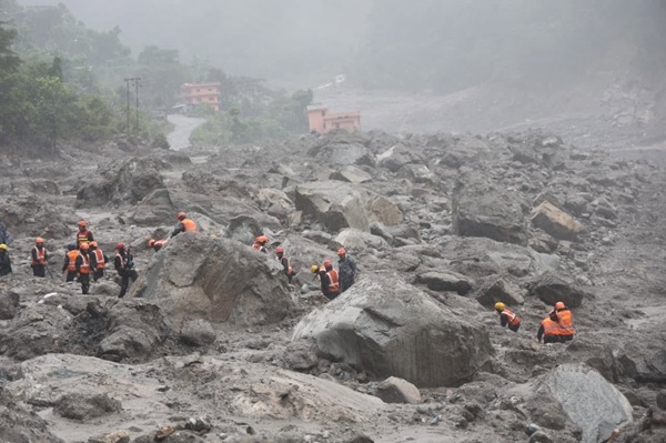
This was not primarily a story of excessive water descending from the skies. Current scientific assessment points towards a massive slope failure involving glacier ice high in the mountains, which rapidly transformed into a debris flow and flood. The US Geological Survey estimates that the resulting mass travelled more than 100 kilometres. The seismic energy generated by the initial collapse was equivalent to an earthquake of magnitude 5.2.
The distinction matters because the Himalayas appear to be confronting a class of hazards which our public vocabulary, and perhaps our disaster preparedness, has yet to absorb adequately.
It is the Debris that Kills
What eventually emerges into inhabited areas is therefore not simply a flood. It is a fast-moving mass of water, mud, shattered rock, ice and vegetation. A conventional flood may inundate a structure. A high-energy debris flow can demolish it.
Large avalanches also displace enormous volumes of air. The resulting air blast can damage or flatten vegetation beyond the principal path of the avalanche itself.
Mountain geography magnifies everything. The narrow valleys which naturally channel the debris are also occupied by roads, bridges, settlements, hydropower projects and people.
Four Warnings from the Himalayas
We have seen variations of this phenomenon before.
On 7 February 2021, the Rishiganga-Tapovan disaster occurred on a clear winter morning in Uttarakhand. A huge mass of rock, snow and ice broke away near Ronti Peak and plunged approximately 1,800 metres. The impact pulverised the material and generated meltwater, producing the devastating debris flow which struck the Rishiganga and Tapovan hydropower projects. More than 200 people were killed or reported missing.
I subsequently entered the Tapovan tunnel and saw the conditions within. It brought home a brutal reality. Once a confined tunnel fills with sludge and debris, survival becomes extraordinarily difficult unless an air pocket or protected physical space remains. Some workers near a tunnel entrance were rescued by the ITBP; those deeper inside faced an almost impossible situation.
This is why comparisons with the Silkyara tunnel rescue of 2023 can mislead and comparison is inappropriate. Silkyara was essentially a tunnel-collapse and entrapment problem in which the workers retained survivable space. Tapovan involved the violent ingress of debris from an external mountain catastrophe.
South Lhonak in Sikkim in October 2023 followed another sequence. Research indicates that a major landslide entered the glacial lake accompanied by substantial calving of glacier ice. The displacement contributed to moraine failure and the catastrophic GLOF down the Teesta.
Then came Dharali near Harsil, in August 2025. What was initially widely assumed to be a cloudburst has subsequently reportedly been traced by ISRO scientists to the collapse of an exposed ice patch below the Srikanta Glacier. The mass descended through extremely steep terrain, gathering sediment and debris before striking Dharali.
Nepal now gives us a fourth variation. The mechanisms in these events are not identical. That is precisely the point. The family resemblance lies in ice, rock, gravity and water interacting to create cascading destruction downstream.
Permafrost: The Less Visible Threat
One element of this emerging hazard deserves much greater attention; permafrost.
At high altitude, permanently frozen ground and ice within rock fractures can contribute to the stability of mountain slopes. Rising temperatures, repeated freezing and thawing, glacier retreat and changing water penetration can progressively weaken this natural bonding.
Retreating glaciers can also remove support from adjoining mountain slopes and expose rock and ice formations to altered stresses.
We should be cautious about attributing every individual collapse directly to permafrost degradation before scientific investigation establishes it. The precise initiating mechanism of Nepal, for example, continues to be studied.
Yet the broader concern cannot be ignored. Climate change does not simply mean glaciers melting gradually and glacial lakes becoming larger. It can alter the physical stability of the high mountain environment itself.
This demands a wider concept of Himalayan risk; cascading cryospheric hazards. A rock-ice avalanche may enter a lake, generate a displacement wave, breach a moraine, block a river or transform into a debris flow. One event triggers another until the consequences reach populations many kilometres downstream.
We Need a Different Eye in The Sky
For national security, we readily understand persistent surveillance. An eye in the sky watches borders continuously, detecting the smallest movement which might indicate hostile activity.
The Himalayas increasingly require the same philosophy directed towards a very different adversary.
Can satellites detect minute displacement on vulnerable rock-ice faces? Can radar penetrate monsoon cloud and identify changes invisible to optical satellites? Can sensors be emplaced on selected high-risk slopes by expeditions or drones? Can artificial intelligence continuously compare successive imagery and flag abnormal movement?
Dharali makes these questions particularly relevant. Satellite imagery could apparently see changes before the collapse but surmises could not be reliably made. The challenge was recognising which changes represented danger.
Our remote-sensing capability is becoming extraordinarily good at telling us what happened. The next frontier is to make it increasingly capable of telling us what may be about to happen.
Technology does not yet provide near reliable predictions today. The Himalayan arc is vast, vulnerable formations are numerous and failures may occur suddenly. Yet the difficulty of the task cannot become an argument against attempting it.
NDMA Must Lead The Effort
India has already demonstrated the value of bringing different scientific disciplines together after such an event.
Following the Rishiganga-Tapovan disaster, the National Disaster Management Authority constituted an interdisciplinary Joint Study Team. I had the privilege of chairing it and leading its visit to the affected region with nearly twenty scientists and specialists drawn from different disciplines.
The purpose went beyond determining what had happened on one February morning. Glaciology, geology, hydrology, meteorology, remote sensing, engineering and disaster management had to be brought together to understand the sequence and identify what could reduce future losses. The resulting work helped establish that Rishiganga was not a conventional GLOF but a glacier ice-and-rock slide cascading into a massive debris flow.
Five years later, Dharali and Nepal make those questions still more urgent.
NDMA should now lead a national interdisciplinary effort on cascading cryospheric hazards. ISRO and NRSC, the Geological Survey of India, Wadia Institute of Himalayan Geology, Defence Geoinformatics Research Establishment, IMD, Central Water Commission, National Institute of Hydrology, IITs and other relevant institutions possess different parts of the knowledge required.
The objective should extend beyond monitoring known glacial lakes. India needs a dynamic inventory of vulnerable hanging glaciers, exposed ice patches, unstable rock-ice faces and permafrost-affected slopes, connected to mapping of the valleys, infrastructure and concentrations of people lying downstream.
Until Technology Catches Up
Technology will take time. Lives have to be protected meanwhile.
Selected high-risk valleys containing hydropower projects, important roads or major pilgrimage routes could have trained mountain patrols positioned upstream during periods of heightened vulnerability. Specially trained and motivated State Disaster Response Force teams, equipped with reliable and redundant communications, could perform this role.
They will not predict an ice collapse. But once an ice fall, avalanche or debris flow has begun, detection sufficiently upstream may provide precious minutes to stop traffic, halt work, sound alarms and direct people towards higher ground.
Thirty minutes can matter enormously. An hour can save hundreds of lives.
The pilgrimage dimension makes this especially important. Millions enter Himalayan valleys annually for the Char Dham Yatra and other sacred journeys. The Nepal tragedy too affected Indian pilgrims travelling towards Kailash-Mansarovar. These are moving populations which cannot be protected like fixed infrastructure.
The answer cannot be fear of the mountains or curtailment of pilgrimage. There must be better assessment of risk, controlled movement, when necessary, reliable warning and public understanding of what to do when an alert comes.
Rishiganga, South Lhonak, Dharali and Nepal are warnings against forcing every Himalayan disaster into the familiar categories of flood, cloudburst or even GLOF. We are confronting interactions between ice, rock, water, gravity and a changing high-altitude environment which can produce different chains of events but devastatingly similar consequences.
The next advance in Himalayan disaster management may therefore come from learning to watch the mountains themselves. India has the scientific capability to begin doing so. NDMA has the institutional ability to bring that capability together. The need now is to make it a mission.
In disaster management, knowledge acquires its greatest value when it buys time. And time saves lives.
More From BasisPoint