.png)
Rethinking Development Resilience in the Himalayan Arc
There is an urgent need for resilient, sustainable development in the Himalayas—balancing security, ecology, and livelihoods through innovation, monitoring, and civil–military cooperation.

Lt Gen Syed Ata Hasnain is a former Commander of India’s Kashmir Corps and Chancellor of the Central University of Kashmir.
August 13, 2025 at 4:28 AM IST
The Himalayan arc stretching across the virtual roof of the world, and often referred to as part of the Third Pole, is facing a future that is changing faster than most of us can imagine. Cloudbursts, landslides, flash floods, and glacial-lake outbursts are no longer rare events. They are arriving more often, sometimes in clusters, with one disaster triggering another.
Climate change, along with the speed and scale of development needed to connect, protect, and power our remote border areas, is pushing this. The question is no longer whether to develop, but how to do it in a way that stands strong when nature tests us. The Government cannot leave the people from the region to develop and secure themselves in isolation; instead, it must adopt a doctrine of sustainable development grounded in resilience.
Roads, bridges, power projects, and tunnels are lifelines for people and for national security. They help keep communities thriving in places where life is not easy, and they are vital for maintaining readiness along a long and active border. This is even more important now, with China building hundreds of “model border villages” to cement its own footprint. For India, the challenge is to continue building while making sure that these assets remain safe and functional during extreme events.
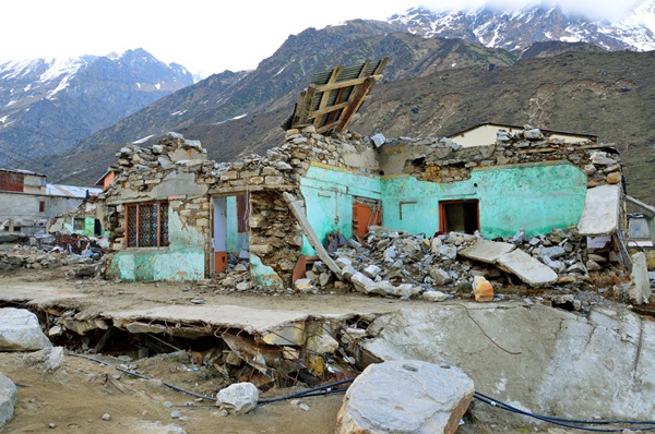
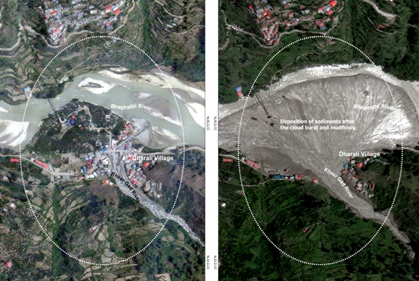
Recent years have reminded us of what is at stake. In February 2021, an icefall in Chamoli, Uttarakhand, led to debris flow that destroyed the Tapovan hydroelectric project. In October 2023, the bursting of a glacial lake in Sikkim led to the failure of the Chungthang dam. In August 2025, flash floods near Dharali in Uttarkashi disrupted a route used by both pilgrims and security forces. These were not freak accidents. They were signs of how vulnerable some mountain systems have become, affecting life, livelihoods, and national security.
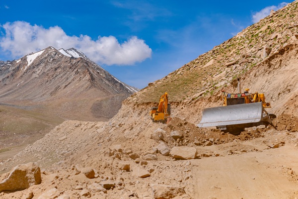
India’s border with China is long, contested, and increasingly active. The need to match adversary capabilities and maintain year-round access is undeniable. However, this must not blind us to the ecological consequences of aggressive construction on unstable mountain slopes. If roads are blocked by landslides or floods, vital supply lines to forward areas remain disrupted. Military convoys can be stranded, air operations delayed, and communications non-functional. Even a short closure can create windows of vulnerability that others might seek to exploit.
The risks are not only to soldiers, pilgrims, and mountain people; they are to the entire effort of keeping our high-altitude borderlands connected, inhabited, and productive.
Every infrastructure project in the Himalayas should undergo rigorous disaster-risk scrutiny before approval. These assessments must not be treated as mere paperwork but as essential tools to determine the safest alignment, the most stable engineering designs, and adequate protective measures. Slope stabilisation, for example, is often underestimated but remains critical; many blockages and accidents occur because steep, fragile slopes are cut without proper reinforcement. Regular monitoring, drainage management, vegetation cover, and protective barriers can greatly reduce the risk of catastrophic collapses.
Understanding the flow of water, snow, and debris during extreme events is equally important. This demands detailed hazard maps of high-risk mountain zones, widely shared with both civilian and military authorities. Satellite imagery and drones provide valuable perspectives, but they must be complemented by ground-based instrumentation in the upper reaches to give real-time warnings.
This is especially vital for the monitoring of glaciers and glacial lakes, which are among the most dynamic and potentially dangerous features in the Himalayas. Identifying the most vulnerable lakes, maintaining updated inventories, and having plans in place to safely drain or reinforce them are crucial measures.
Similarly, monitoring mountain slope stability using ground sensors, GPS-based deformation tracking, and regular geological surveys can help detect early signs of movement before a landslide occurs. Instrumentation for seismicity—such as dense networks of seismometers and accelerometers—should be installed not just to study earthquakes but also to link with landslide and avalanche risk assessments. Given that avalanches can threaten both civilian settlements and vital military positions, avalanche early-warning systems that integrate snowpack analysis, weather data, and remote sensing need to be operational in all high-risk corridors.
The India Meteorological Department should lead an inter-agency early-warning mechanism, ensuring that the right information reaches the right people in time. This includes deploying a higher number of Doppler weather radars across different valleys, especially those prone to cloudbursts and heavy snowfall. These radars, combined with high-altitude rain and snow gauges, can track fast-developing storms and feed data into real-time alert systems.
However, warning systems alone are not enough. They must be backed by operational capacity—trained personnel, clear protocols, and rapid deployment resources. This is why a search and rescue setup involving the Armed Forces, Central Paramilitary Forces, the National Disaster Response Force, and State Disaster Response Forces must be maintained on a long-term basis. Pre-positioned equipment, rehearsed coordination drills, and mobile rescue teams can make the difference between a contained emergency and a large-scale tragedy.
Early warning systems can save lives and prevent damage if they are linked to decisive action. Alerts must instantly reach road crews, district officers, local leaders, and army posts. Mock exercises should be conducted regularly so that when a warning comes, every person and agency knows their role, from evacuating vulnerable areas to securing infrastructure.
The importance of civil and military agencies working together both to plan, develop, and maintain this infrastructure cannot be overplayed. The National Disaster Management Authority has already taken steps towards this integrated approach, including hosting a national-level symposium between the Army’s Corps of Engineers and multiple disaster agencies to align operational priorities and knowledge sharing.
Border communities are the anchor of our presence in these high-altitude regions. If their livelihoods collapse and migration begins, local economies weaken and national security erodes. The solution lies in safe, in-situ development—offering viable opportunities without forcing people to move. This means promoting tourism that respects environmental limits, supporting traditional farming and crafts, and enabling small-scale, eco-friendly enterprises that keep people connected to their land.
Finance also plays a decisive role in disaster readiness. Not all risks can be eliminated, but they can be managed if funds are available and rules are clear. Quick-access emergency repair funds, risk insurance for specific hazards, and reserve pools for rare but high-impact events must be institutionalised. Every infrastructure project should earmark part of its budget for slope protection, long-term maintenance, and routine safety audits.
Large power projects and tunnels, while essential in some contexts, must be treated with exceptional caution in the Himalayas. In certain valleys, smaller, decentralised power schemes may be safer and more sustainable. Where large dams or long tunnels are unavoidable, continuous upstream monitoring, conservative operation during heavy rainfall, and multiple evacuation routes are non-negotiable. Tunnels, in particular, should have emergency shelters, alternative communication channels, and clearly marked escape routes, all tested through regular drills.
Finally, strategic planning must prepare for the inevitable day when a critical route is closed. This means identifying and maintaining alternate tracks, storing temporary bridges for rapid deployment, ensuring forward stockpiles of fuel and food, and keeping emergency airstrips and helipads operational. In today’s interconnected world, redundant communication systems are not luxuries, they are lifelines.
Every major incident should be followed by a structured review process to capture lessons learned and feed them directly back into engineering designs, contractual requirements, and training curricula. Over time, these iterative improvements will strengthen both our infrastructure and our institutional capacity to adapt.
The Ministry of Home Affairs and the National Disaster Management Authority are seized of the importance and the challenges of the mountains. The readiness and speed of response to the recent Dharali disaster is an example. However, they are now also equally seized of the need for furthering our mitigation measures with the stronger financial backing that the Finance Commissions have offered.
The Himalayas is far more than a natural barrier; it is a living home for millions and the backdrop for some of our most critical national efforts. By embedding comprehensive monitoring systems, stabilising what we build, coordinating civil and military responses, and preparing for the hazards we cannot prevent, we can ensure that development strengthens rather than undermines our strategic position. The aim is simple yet profound: keep our people safe, keep our roads and bridges open, and keep our borderlands alive and thriving on the roof of the world.
More From BasisPoint